

Focus on Contra Costa County
Scenarios
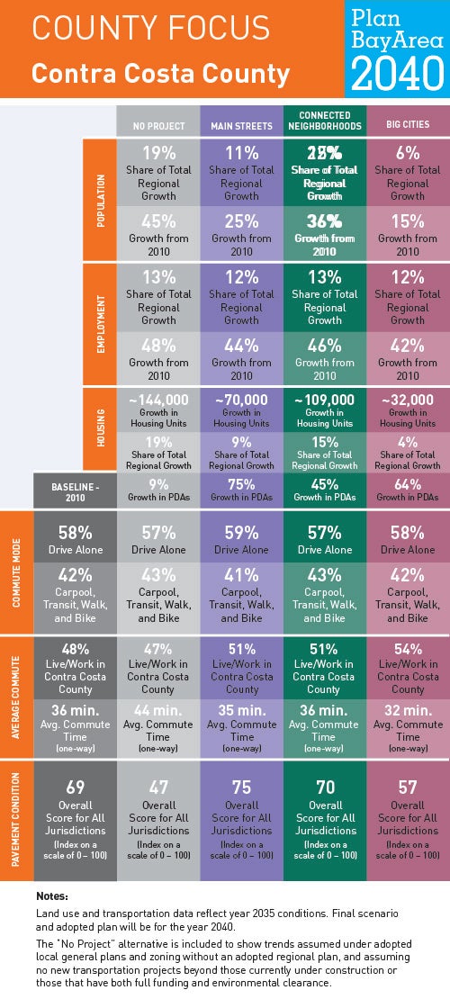
To help us understand where current and future Bay Area residents will live, work and get around in Contra Costa County and beyond, planners at MTC and ABAG have generated forecasts for jobs, housing, population, travel demand and transportation revenue. To show how these forecasts might play out over time—and to ensure the Plan is meeting the goals Bay Area residents helped identify in 2015—planners have developed three scenarios. Understanding how these three planning scenarios will impact life in Contra Costa County helps us recognize what issues may become most important as a preferred scenario is developed and Plan Bay Area updated.
Locally Adopted Priority Development Areas (PDAs) and Priority Conservation Areas (PCAs)
Located across the Bay from San Francisco and Marin County, Contra Costa County has grown to be the third most populous county in the Bay Area region; the county’s natural beauty and its strategic location between the San Francisco Bay and California’s Central Valley have long attracted residents and businesses. New jobs and housing are expected to cluster along the county’s major transit thoroughfares, including San Pablo Avenue in the western part of the county, and around the ten BART stations in Contra Costa County. Click on the link to view five examples of the 38 locally adopted PDAs in Contra Costa County.