

Focus on Napa County
Scenarios
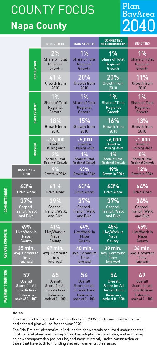
To help us understand where current and future Bay Area residents will live, work and get around in Napa County and beyond, planners at MTC and ABAG have generated forecasts for jobs, housing, population, travel demand and transportation revenue. To show how these forecasts might play out over time—and to ensure the Plan is meeting the goals Bay Area residents helped identify in 2015—planners have developed three scenarios. Understanding how these three planning scenarios will impact life in Napa County helps us recognize what issues may become most important as a preferred scenario is developed and Plan Bay Area updated.
Locally Adopted Priority Development Areas (PDAs) and Priority Conservation Areas (PCAs)
Napa County is internationally acclaimed for its winemaking and the picturesque Napa Valley wine region is a major draw for visitors to the San Francisco Bay Area. The valley is bounded by rolling hills, and the Napa River empties into San Pablo Bay through the narrow Mare Island Strait. Napa County has strong policies to prioritize agricultural uses and to protect farmlands, watersheds and open space. Accordingly, more than 90 percent of unincorporated county land falls within those designations. The county seeks to continue to protect these lands and encourage recreation through its nine Priority Conservation Areas. Most nonagricultural development is clustered in the four cities and one town connected by Highway 29, which parallels the Napa River in the western part of the county. Click on the link to view highlights of the two locally adopted PDAs in Napa County.